As you may or may not know. We are in process in creating a new A.V.A. for the Ballard Canyon Reigon of the Santa Ynez Valley.
Our Windmill Ranch Vineyard (fathers vineyard) is the Entry to this new Ballard Canyon AVA.
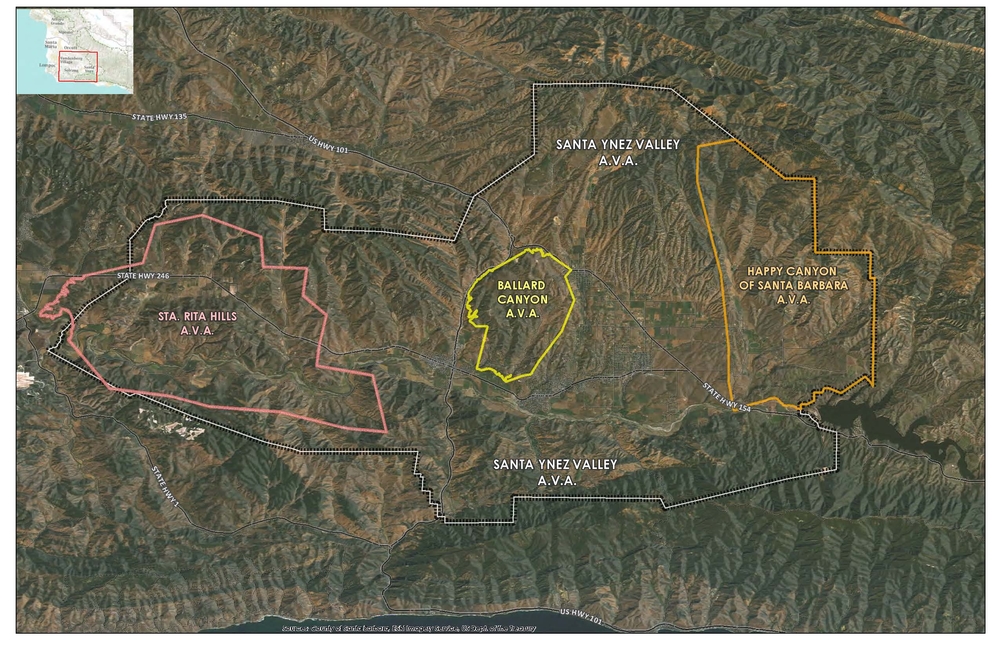
I had the acreage of each AVA or proposed AVA surveyed and wanted to pass on the results for whatever use you can find:
Santa Ynez Valley: 180,828.513571 Acres
Santa Rita Hills: 33,355.471352 Acres
Happy Canyon SB: 26,064.2044092
Ballard Canyon: 7,793.38180404
Note Ballard is about 1/4 the size of SRH, and just larger than 30% of Happy Canyon, or 4% of the SYV AVA. Of course Ballard Canyon is proposed, not official, and this is just the proposed boundary.
Wes Hagen, Vineyard Manager/Winemaker
Clos Pepe Vineyards and Estate Wines
Bottom line, our little area is
An American Viticultural Area is a designated wine grape-growing region in the United States distinguishable by geographic features, with boundaries defined by the Alcohol and Tobacco Tax and Trade Bureau (TTB), United States Department of the Treasury. The TTB defines AVAs at the request of wineries and other petitioners. There were 198 AVAs as of January, 2010.[2] Prior to the installation of the AVA system, wine appellations of origin in the United States were designated based on state or county boundaries. All of these appellations were grandfathered into federal law and may appear on wine labels as designated places of origin, but these appellations are distinct from AVAs.
Current regulations impose the following additional requirements on an AVA:[citation needed]
- Evidence that the name of the proposed new AVA is locally or nationally known as referring to the area;
- Historical or current evidence that the boundaries are legitimate;
- Evidence that growing conditions such as climate, soil, elevation, and physical features are distinctive;
Petitioners are required to provide such information when applying for a new AVA, and are also required to use USGS maps to both describe (using terms from the map) and depict the boundaries.